Port St. Lucie to Orlando From Brystol at Wylder: The Turnpike Exit by Exit
In this article
The main road from Port St. Lucie to Orlando is Florida's Turnpike, heading north. From Brystol at Wylder, you reach it from the west side of the city, and the Turnpike takes you all the way to the Orlando interchanges, including the one for I-4. Lennar describes Brystol as sitting ""right between Palm Beach County and Orlando,"" and Wylder's developer says the master plan has convenient access to both I-95 and the Turnpike.
This guide lists the Turnpike exits and service plazas between Port St. Lucie and Orlando, using the official Florida's Turnpike system map. It names roads only. Traffic changes by the hour, so we do not give drive times.

Why Orlando Comes Up So Often
Both the builder and the developer point to Orlando when they describe this location. Lennar says Port St. Lucie is ""close to everything, yet blissfully away from it all,"" and places Brystol between Palm Beach County and Orlando. Wylder's developer says the community sits ""roughly midway between Miami and Orlando.""
For a buyer, that is a real choice to weigh. Living here puts both South Florida and Central Florida within reach by highway, but it also means you will use the highways often. The Turnpike is the road most of those trips start on.
Getting From Brystol to the Turnpike
Brystol is on NW Suncrest Loop, in Wylder. Wylder's developer places the community just west of I-95, between Midway Road and Glades Cut-Off Road. That puts you on the west side of Port St. Lucie, with both I-95 and the Turnpike within reach.
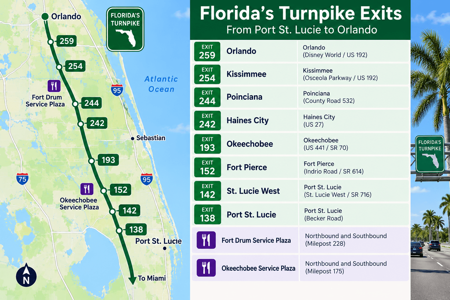
The official Florida's Turnpike system map shows these interchanges in the Port St. Lucie and Fort Pierce area:
Exit | Name on the official map |
|---|---|
138 | Becker Rd. |
142 | Port St. Lucie (Port St. Lucie Blvd.) |
152 | Fort Pierce (S.R. 70) |
Use a live map app on the day you drive to pick the right one from your home. Your choice can change with road work and with where in Wylder your home sits.
For the local roads around Wylder itself, our map of the roads around Wylder and Glynlea names them one by one.
Port St. Lucie to Orlando, Exit by Exit
Heading north from Port St. Lucie, the official map lists these stops along the Turnpike mainline:
Exit or plaza | What it is |
|---|---|
144 | Port St. Lucie/Fort Pierce Service Plaza |
152 | Fort Pierce (S.R. 70) |
184 | Fort Drum Service Plaza |
193 | Yeehaw Junction (S.R. 60) |
229 | Canoe Creek Service Plaza |
240 | Clay Whaley Rd. |
242 | Kissimmee-St. Cloud South (U.S. 192 and U.S. 441) |
244 | Kissimmee-St. Cloud North (U.S. 192 and U.S. 441) |
249 | Osceola Pkwy. |
251 | S.R. 417 |
254 | Orlando South (U.S. 17/92/441) |
259 | Orlando (I-4) |
263 | Turkey Lake Service Plaza |
A few notes on that list:
Service plazas are where you stop for fuel, food and restrooms without leaving the Turnpike. The map shows four between Port St. Lucie and the Orlando area: Port St. Lucie/Fort Pierce, Fort Drum, Canoe Creek and Turkey Lake.
Kissimmee and St. Cloud come before Orlando. If your trip ends there, exits 242 and 244 are the ones to watch.
Exit 259 is the interchange with I-4.
The Beachline West and East expressways also appear on the official map in the Orlando area. Check the map for the exact interchange you need.
Tolls on the Turnpike
Florida's Turnpike is a toll road, and the official map marks which interchanges collect tolls. Toll amounts change and depend on how you pay. Use the Florida's Turnpike toll calculator to price your exact trip before you go. If you will make the trip often, add the tolls to your monthly budget along with fuel, the same way you would plan for any regular commute.

Checking Traffic Before You Leave
Traffic can slow down anywhere on the trip, and crashes or road work can close lanes. FL511, which calls itself Florida's official source for real-time traffic information, has a live traffic map, incident details, traffic cameras and construction information. Check it before a long trip, and especially before a flight.
What About Going South?
If you work or shop in Palm Beach County, that trip has two choices, I-95 and the Turnpike, and each has its own exits. Our guide to getting from Port St. Lucie to West Palm Beach compares them.
For a closer look at the I-95 exits that serve the west side of the city, see our I-95 exits and roads guide from Central Park.
Who Benefits Most From This Location
Living on the west side of Port St. Lucie works well if you:
travel to Orlando often for work, family, theme parks or flights;
split your time between the Treasure Coast and Central Florida;
want quick access to both I-95 and the Turnpike from home.
If most of your trips stay inside Port St. Lucie, the I-95 side of town matters more. Our guide to St. Lucie West and daily life near Brystol covers the shopping, dining and baseball close by.

Planning a Move From Orlando?
If you are moving from Orlando to Port St. Lucie, plan a weekend to tour Brystol and see the area. Start at the model homes, drive the roads around Wylder, and spend an afternoon in St. Lucie West. For the bigger picture on the city, read our Port St. Lucie new homes guide for Brystol buyers.
A Simple Trip Checklist
Before you head north, run through this list:
Check FL511 for crashes, road work and lane closures on the Turnpike.
Price the tolls with the Florida's Turnpike toll calculator.
Pick your interchange from home with a live map app.
Plan a stop. Fort Drum and Canoe Creek are the two service plazas in the long stretch between Port St. Lucie and Kissimmee on the official map.
Know your exit. Kissimmee and St. Cloud use exits 242 and 244, Orlando South is exit 254, and I-4 is exit 259.
If you fly often, FL511 also has a transit and airports section, so you can check conditions before you leave for the airport.
Common Questions
What is the best road from Port St. Lucie to Orlando?
Most drivers use Florida's Turnpike north. It runs from the Port St. Lucie area to the Orlando interchanges, including exit 259 for I-4.
Which Turnpike exits serve Port St. Lucie?
The official Florida's Turnpike map lists exit 138 for Becker Rd., exit 142 for Port St. Lucie Blvd., and exit 152 for Fort Pierce on S.R. 70.
Are there rest stops on the Turnpike to Orlando?
Yes. The official map shows service plazas at Port St. Lucie/Fort Pierce, Fort Drum, Canoe Creek and Turkey Lake.
Is the Turnpike a toll road?
Yes. Use the Florida's Turnpike toll calculator to price your trip, since amounts change and depend on how you pay.
How long is the drive from Port St. Lucie to Orlando?
It changes with traffic, so we do not quote a time. Check FL511 or a live map app before you leave.
Is Brystol at Wylder close to the Turnpike?
Wylder's developer says the master plan has convenient access to I-95 and Florida's Turnpike. Use a live map app to find the best interchange from your homesite.
Does the Turnpike go through Kissimmee?
Yes. The official map lists exit 242 for Kissimmee-St. Cloud South and exit 244 for Kissimmee-St. Cloud North, both at U.S. 192 and U.S. 441.
Where can I stop for gas on the way to Orlando?
The official map shows service plazas at Port St. Lucie/Fort Pierce, Fort Drum, Canoe Creek and Turkey Lake along the Turnpike mainline.
Visit Brystol on Your Next Trip
Coming down from Orlando? Call 561-704-0091 or reserve a Brystol at Wylder model tour for the day you arrive. We will have the plans and homesites ready for you.
You can also browse the Brystol at Wylder floor plans online.
Related reading: St. Lucie West: Daily Life, Schools and Things to Do Near Brystol at Wylder; New Homes in Port St. Lucie, FL: A Buyer's Guide to Brystol at Wylder; Map of Port St. Lucie: The Roads Around Glynlea Country Club.