Map of Port St. Lucie: The Roads Around Glynlea Country Club
In this article
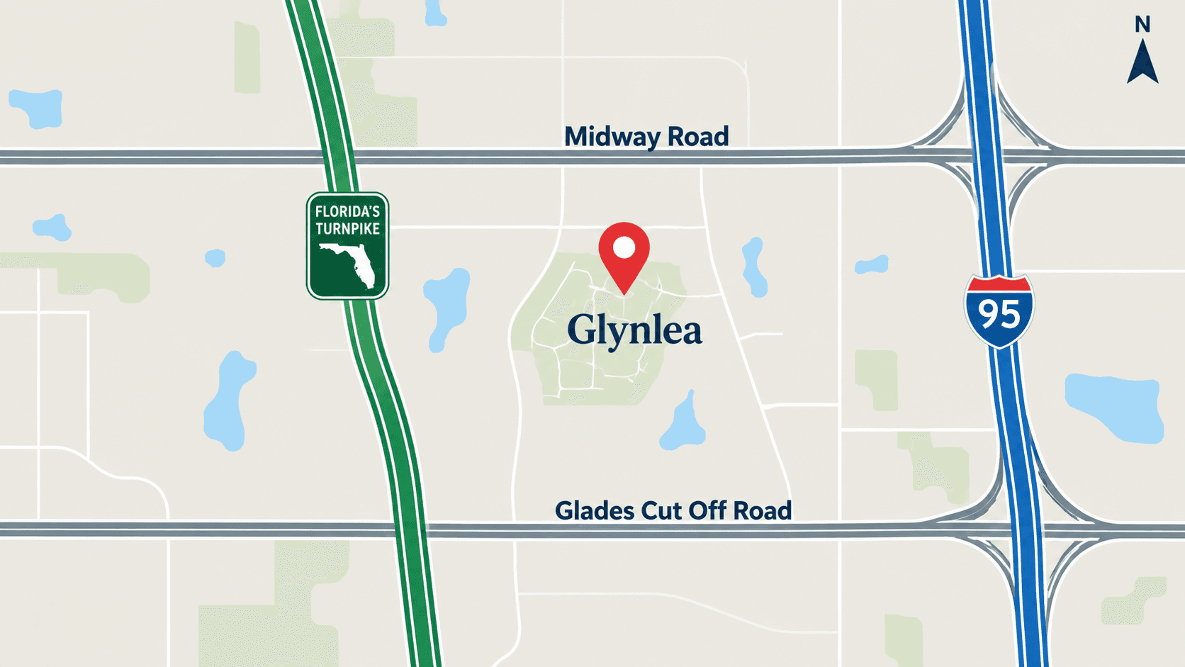
A map of Port St. Lucie makes more sense once you know three things: I-95 and Florida's Turnpike both run north and south through the city, locals use area names like Wylder and Tradition more than street names, and Glynlea Country Club sits on the west side inside the Wylder master plan. This guide names the roads around Glynlea and shows you the free map tools that let you check any address yourself.
Where Glynlea Sits on a Map of Port St. Lucie
Lennar lists Glynlea Country Club's sales address as 6727 NW Glynlea Blvd South, Port St. Lucie, FL 34987. The club's own site lists the golf club at 10942 NW Furyk Drive, Port St. Lucie.
Glynlea is inside Wylder. The developer, GreenPointe, says Wylder is located ""between Midway Road and Glades Cut Off Road in Port St. Lucie."" So when you open a map, find those two roads first. Glynlea sits in the land between them on the west side of the city.
New to the area? Our Port St. Lucie buyer's guide for Glynlea gives the big picture first.

The Main Roads Around Glynlea
We never give drive times. Traffic changes too much by hour and season. Instead, here are the roads to know, with where each fact comes from.
Road | Why it matters | Source |
|---|---|---|
NW Glynlea Blvd | Lennar's sales address is on it | Lennar |
NW Furyk Drive | The golf club's address | Glynlea Country Club site |
Midway Road | One edge of Wylder, per the developer | GreenPointe |
Glades Cut Off Road | The other edge of Wylder, per the developer | GreenPointe |
NW Wylder Parkway | A named road inside Wylder on OpenStreetMap | OpenStreetMap |
Florida's Turnpike | Toll road; the developer says Wylder has access to it | GreenPointe |
I-95 | Main north-south interstate; the developer says Wylder has access to it | GreenPointe |
Midway Road
Midway Road matters for more than driving. St. Lucie Public Schools uses Midway Road as one of its school-zone dividing lines. We explain that in our Wylder daily-life and schools guide.
Florida's Turnpike and I-95
Port St. Lucie has two big north-south highways. Florida's Turnpike is a toll road. I-95 is not. Many people use one for some trips and the other for different trips. The Turnpike's official site, Florida's Turnpike, has toll and travel information.
The Turnpike site lists SunPass electronic toll collection, TOLL-BY-PLATE and a toll calculator. If you will use the Turnpike often, set up your toll account before you move, so the first bills do not surprise you.
A few simple rules of thumb for picking a route:
Use a map app at the real hour. A route that looks short at noon can be slow at 7:30 a.m.
Try both highways once. Drive your work trip on the Turnpike one day and I-95 the next.
Note the entry points. Learn which interchange you would use for each highway, so you are not guessing on your first busy morning.
Heading south for work or flights? Read the Turnpike and I-95 routes from Port St. Lucie to West Palm Beach, which lists the exits and connector roads.
Free Map Tools You Can Use
You do not need to guess where a homesite is. Two public tools help:
St. Lucie County Property Appraiser map. The Property Appraiser's interactive map lets you look up parcels. It is useful once you know a lot number or address.
St. Lucie Public Schools locator. The district's Student Assignment page links to its interactive school map.
Use a regular phone map for driving routes, and check them at the time of day you would really drive.

Map Words You Will Hear
Port St. Lucie is big, and locals use area names more than street names. A few you will hear:
Wylder: the master plan that holds Glynlea Country Club.
Glynlea: the golf neighborhood inside Wylder.
Tradition and St. Lucie West: other large named areas of the city with their own shops and roads.
Central Park: another named area with newer homes.
When someone uses one of these names, ask which roads they mean. If you want help placing Central Park and the I-95 exits, see how drivers reach Central Park from the I-95 exits. It shows how the exits connect to neighborhood roads.
Getting to the Beach and Water
As our beaches guide explains, there is no ocean beach inside Port St. Lucie. The nearby ocean beaches are on Hutchinson Island. Lennar points buyers to Jetty Park in Fort Pierce, which it describes as having ""a beach, fishing pier, playground, picnic tables and picturesque sunset views.""
For a full list of beaches and how to reach them, see where to find a beach near Port St. Lucie.
Airports
The Glynlea Country Club marketing site's location page says access to I-95 and the Turnpike puts ""Palm Beach International and Orlando International airports well within reach."" That is the marketing site's wording. Check your own route and timing with a map app before you plan around a flight.
Fun Places on the Map
A few places buyers ask about:
Clover Park. Lennar calls it ""the home of the St. Lucie Mets and the spring training home of the New York Mets.""
The Glynlea golf course and range. Read what the over-water Toptracer range at Glynlea is like.

Storm Maps Are Maps Too
A Florida buyer needs one more map: the evacuation zone map. The Florida Division of Emergency Management's plan and prepare pages include a ""Know Your Zone, Know Your Home"" section. Look up the exact address you are buying, write the zone down, and keep it with your storm supplies.
A Map-Day Plan for Buyers
Before you buy, spend one day driving:
Start at the Glynlea sales address on NW Glynlea Blvd.
Drive out to Midway Road, then to Glades Cut Off Road, so you know both edges of Wylder.
Drive to the Turnpike and to I-95. Note which one you would use for work.
Find the closest grocery store, pharmacy and urgent care.
Look up the homesite on the Property Appraiser map.
Check the school zone for the exact address with the district.
Common Questions
Where is Glynlea Country Club in Port St. Lucie?
On the west side of the city, inside the Wylder master plan. Lennar lists the sales address as 6727 NW Glynlea Blvd South, Port St. Lucie, FL 34987.
What roads border Wylder?
The developer, GreenPointe, says Wylder is located between Midway Road and Glades Cut Off Road.
Is Glynlea near I-95 and Florida's Turnpike?
The developer says Wylder offers access to I-95 and the Florida Turnpike. We do not give drive times, so map your own route at the hour you would drive.
Does Port St. Lucie have a beach?
Not an ocean beach inside the city. The nearby ocean beaches are on Hutchinson Island. Lennar mentions Jetty Park in Fort Pierce.
How can I look up a homesite on a map?
Use the St. Lucie County Property Appraiser's interactive map at map.paslc.gov once you have the address or parcel.
Why does Midway Road matter for schools?
St. Lucie Public Schools uses Midway Road and Florida's Turnpike as dividing lines for its elementary and middle school zones. Check the exact address with the district.
Want a guided drive of the area? Call 561-704-0091 or book a Glynlea visit. Floor plans and photos are on our Glynlea plans and photos page.
Related reading: Port St. Lucie, FL: A Buyer's Guide to Glynlea Country Club · Wylder Port St. Lucie: Daily Life, Parks and Schools Around Glynlea · Toptracer Range at Glynlea: How the Over-Water Driving Range Works