Where Is Florida City? The Roads Around Del Mar, Explained
In this article
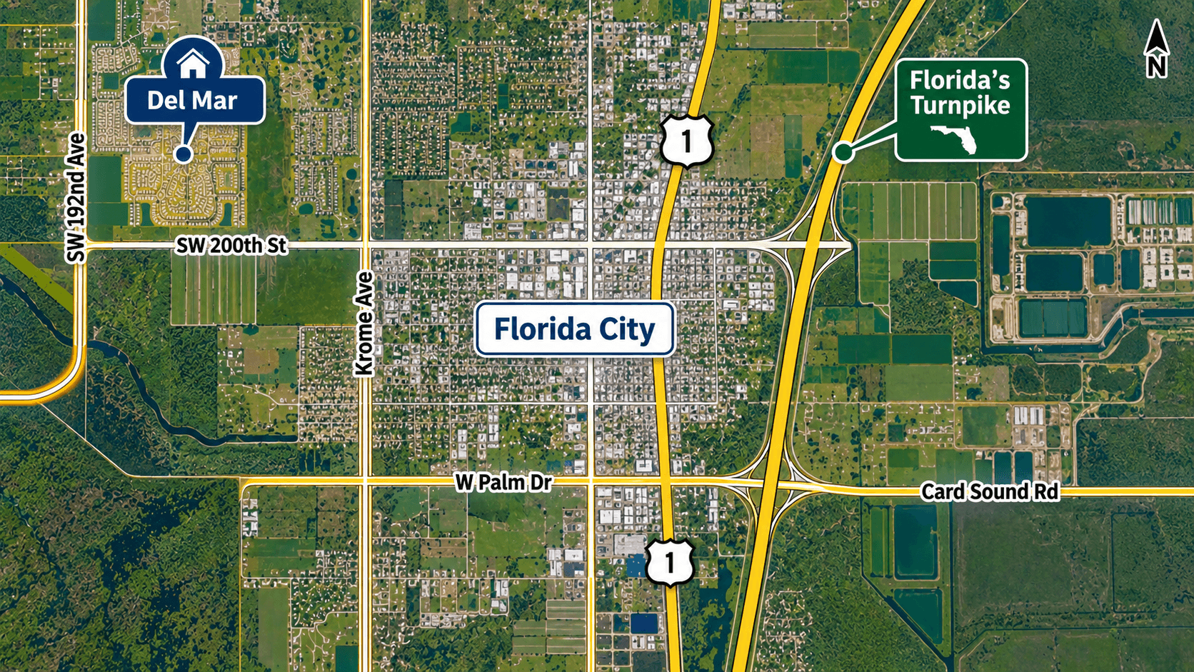
Florida City is in the far south of Miami-Dade County, where Florida's Turnpike ends at US 1 and the roads to the Florida Keys and Everglades National Park begin. Lennar's Del Mar townhomes sit on SW 180th Avenue, in the area the county labels Florida City. This guide explains where that is, how the county's street numbers work and which named roads connect Del Mar to everything else.

Where Is Florida City?
Florida City is a small city in south Miami-Dade County, next to Homestead. Wikipedia describes it as ""the southernmost municipality in the South Florida metropolitan area."" It also says Florida City is ""the southernmost city in the United States which is not on an island.""
Three things make Florida City easy to find on a map:
Florida's Turnpike ends there. The Homestead Extension of Florida's Turnpike, State Road 821, ""begins at its south end at a partial interchange with US 1 in Florida City.""
The road into the Keys starts there. The stretch of US 1 to Key Largo is known as the 18-Mile Stretch. A Florida Department of Transportation project title describes it as the ""18-Mile Stretch of US 1 Between Florida City and Key Largo.""
The road to Everglades National Park runs through it. State Road 9336 follows West Palm Drive through Florida City toward the park.
The city's own website is floridacityfl.gov. For what the shared 33034 ZIP code covers, read what the 33034 ZIP code includes.
Where Del Mar Sits
Del Mar's address is 35605 SW 180th Avenue. Lennar lists it as ""Miami, FL 33034.""
Miami-Dade Property Appraiser records for Del Mar homesites list them as ""Unincorporated County,"" with the neighborhood labeled ""Florida City."" So Del Mar is in unincorporated Miami-Dade, in the Florida City area, but not inside the city limits. You can see the exact spot on Del Mar's page, with its map.
How Miami-Dade Street Numbers Work
Once you know the grid, you can place almost any address in the county.
Avenues run north and south. In the southwest part of the county, the numbers grow as you go west. Miami Avenue is the dividing line between east and west.
Streets run east and west. In the southwest part of the county, the numbers grow as you go south. Flagler Street is the dividing line between north and south.
House numbers follow the grid. A house number like 35605 on an avenue points to the block near SW 356th Street.
So for Del Mar:
SW 180th Avenue is just west of SW 177th Avenue, which is Krome Avenue.
SW 356th Street is south of SW 344th Street, which is Palm Drive.

The Main Roads Around Del Mar
These are the named roads you will use most. We do not give drive times, because they change with traffic. Check a live map for your own trips.
Krome Avenue (SW 177th Avenue). Krome Avenue is the name for SW 177th Avenue, a north-south road a few blocks east of Del Mar. A highway guide describes Krome Avenue as tying ""into U.S. 1 along the Florida City line."" Our guide to Krome Avenue's history and route explains how the road works and its history as State Road 997.
Palm Drive (SW 344th Street). Palm Drive is an east-west road through Florida City. The National Park Service describes SW 344th Street as ""Palm Drive, the last light before the Florida Turnpike entrance."" US 1 crosses Palm Drive at the east end of State Road 9336.
State Road 9336. The Florida Department of Transportation, as quoted on Wikipedia, says State Road 9336 ""begins at the entrance to the Everglades National Park."" The route follows West Palm Drive through Florida City.
US 1 (Dixie Highway). US 1 runs north from Florida City through Homestead toward Miami. South of Florida City, it becomes the 18-Mile Stretch to Key Largo.
Florida's Turnpike. The Homestead Extension starts at US 1 in Florida City and heads north through the county.
Card Sound Road (County Road 905A). This is the other road into the Keys. Wikipedia says it ""has its northern terminus at an intersection with US 1 in Florida City."" For a turn-by-turn look at both routes south, read our guide to the turn-by-turn drive from Homestead to Key West.
The Roads at a Glance
Road | Runs | What it connects |
|---|---|---|
Krome Avenue (SW 177th Ave) | North-south | Ties into US 1 along the Florida City line |
Palm Drive (SW 344th St) | East-west | Carries State Road 9336 through Florida City toward Everglades National Park |
US 1 (Dixie Highway) | North-south | Homestead and Miami to the north, the 18-Mile Stretch to Key Largo to the south |
Florida's Turnpike (SR 821) | North-south | Starts at US 1 in Florida City and runs north |
Card Sound Road (CR 905A) | South to the Keys | Starts at US 1 in Florida City |
Keep this table handy for your first few weeks. Once you know these five roads, most trips around south Miami-Dade make sense.
Getting Around Without a Car
Miami-Dade runs an electric bus rapid transit line in south Miami-Dade. The county says it ""will run along a dedicated 20-mile corridor from the SW 344th Street Park-and-Ride in Florida City to Dadeland South Metrorail Station."" At Dadeland South, riders can switch to Metrorail. Check the county's transit page for routes and schedules.
Two National Parks on Your Doorstep
Florida City sits between two national parks.
Everglades National Park. The Ernest F. Coe Visitor Center is at 40001 State Road 9336, according to the Park Service.
Biscayne National Park. The Park Service lists the park at 9700 SW 328th Street in Homestead. See our Biscayne National Park visitor guide.
For a wildlife stop much closer to home, read about Everglades Outpost, the wildlife sanctuary on SW 192nd Avenue.

What This Means for Buyers
Location is about the trips you make every week. Before you buy at Del Mar, try this:
Drive your work route at rush hour. Do it on a weekday, at the time you would really leave.
Try the Turnpike and US 1 both ways. Some people prefer one, some the other.
Find your nearest busway stop if you would ride transit.
Look up schools by exact address with Miami-Dade County Public Schools. Boundaries can change.
If you are comparing Del Mar with another community in the area, our Lennar vs DR Horton comparison of two Florida City-area townhome communities shows how two nearby choices stack up. For the bigger picture, read our buyer's guide to Florida City and Del Mar.
Common Questions
Where is Florida City, Florida?
In the far south of Miami-Dade County, next to Homestead, where Florida's Turnpike ends at US 1.
Is Del Mar inside Florida City?
County records for Del Mar homesites list them as unincorporated Miami-Dade County, in the neighborhood the county labels Florida City. Lennar uses a Miami, FL 33034 mailing address.
What is the main road near Del Mar?
Krome Avenue (SW 177th Avenue) runs a few blocks east of SW 180th Avenue. Palm Drive, US 1 and Florida's Turnpike are the other main roads in the area.
Where does Florida's Turnpike end?
The Homestead Extension of Florida's Turnpike ends at US 1 in Florida City.
How do you get to the Florida Keys from Florida City?
Take US 1 south along the 18-Mile Stretch to Key Largo, or take Card Sound Road, which starts at US 1 in Florida City.
Is there public transit near Del Mar?
Miami-Dade's bus rapid transit line runs from the SW 344th Street Park-and-Ride in Florida City to Dadeland South Metrorail Station.
How long is the drive to Miami?
It depends on traffic and where in Miami you are going. Check a live map at the times you would travel.
Want to see Del Mar and drive the area with someone who knows it? Call 561-704-0091 or schedule a time to see Del Mar.
Related reading: Florida City FL buyer's guide · Everglades Outpost and daily life near Del Mar · Lennar vs D.R. Horton at Del Mar and Palm Cay